How to · 3 min read · updated
How to make a mountain range pillow of your view
Drop a pin where you stand and face the mountains. The top edge of the pillow is the ridge you'd actually see from there.
The short answer
Pick the exact spot and direction on a map, compute the horizon from elevation data (allowing for the curve of the earth), and cut the pillow along that line. The Skyline does this out to 250 km and labels the peaks you can really see.
How the ridgeline is worked out
The Skyline sends out a line of sight for every sliver of the view, from your eye height over the ground at the pin, and records the highest point each one hits. It reads free public elevation tiles (in the US that's the USGS survey at about 10 m detail) and looks out as far as 250 km.
It also allows for the curve of the earth. After the usual correction for air bending light, a mountain 100 km away sits about 683 m lower than it would on a flat earth, and one 200 km away about 2.7 km lower. That's why far ranges look shorter than their height suggests, and the pillow gets that right.
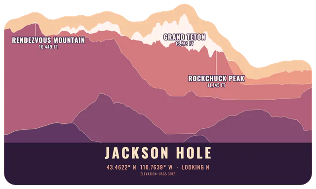
The ridges are recorded in layers by distance, from 1.5 km out to 250 km, and the colours fade as they get further away. That stacked look comes straight from the data.
Why real mountains look flat, and what Drama does
Drawn at true angles, almost every real horizon is close to flat. Mount Rainier seen from Seattle, nearly 100 km away, rises only about 2 degrees above the horizon. So the site lets you stretch the heights, from 1x up to 10x, and it shows you the number. The settings are called honest-ish, proud and heroic. Pick one you can live with when a friend asks if it really looks like that.
Pick the spot carefully
The pin matters more than you'd think. From Jackson's town square the nearby buttes block the Tetons completely, which is true, and the pillow will show you buttes. Go up Snow King and the range is there, 30 to 45 km out. If the view you love is from a deck or a balcony, raise the eye height (it goes from 1 to 60 m) instead of moving the pin.
Peak names come from Wikidata, and a peak is only offered as a label if the line of sight actually reaches it. If a famous summit is missing, it's hidden behind something nearer. You can rename any label.
How close it gets
We checked it against photos. Mount Rainier from Kerry Park in Seattle comes out as a broad dome about 5.6 times wider than it stands above the foothills; measured on the photo it's about 5.7. The Tetons from Mormon Row line up with the photo to within about a degree.
The weakest case is a needle-sharp summit. Elevation tiles shave narrow peaks, so the Matterhorn's tiles top out around 4,355 m when it's 4,478 m. The site raises a labelled summit back to its surveyed height, but the faces still come out softer than the real thing.
What gets cut
The ridge gets a sky-coloured band around it and is smoothed so nothing narrower than 0.75 in sticks out on the 10 in pillow. The bottom is straight with rounded corners. Along the bottom line there's a small credit for the elevation source, because the data licences ask for it. Stickers and magnets in 3, 4 and 6 in use the same ridge with a white border and no credit line.
Questions people ask
Does it work outside the US?
Yes. The elevation tiles cover the whole world, built from national surveys where they exist and satellite data elsewhere. Shipping is US only for now.
Can I make a pillow of the view from the ocean?
The sea counts as a flat floor, so a coastal view gets a flat sea horizon with whatever land rises behind it.
Why is my mountain shorter than I remember?
The curve of the earth and distance both shrink it. Turn up the Drama setting. The site shows the stretch it used, so nobody is fooled.
Can I change the peak names?
Yes, every label is editable. Labels stay at least 0.25 in inside the cut so they don't run into the seam.